

Sam
Super User
-
Joined
-
Last visited
Everything posted by Sam
-
Patience. Need to follow pro's one-hour rule and not pull up and move after 10 minutes on any one area. Patience.
-
I received as a Christmas gift many, many years ago the book, Fishing Tips and Tricks. The publication has over 300 "guide-tested" tips. It also has many of today's techniques shown that we use all the time, such as the wacky rig. The book was published in 1990 by Creative Publishing International, 18705 Lake Drive East, Chanhassen, MN 55317. 800.328.3895 www.creativepub.com I have no ide if this company is still around but you may find a copy of the book on Amazon or eBay.
-
Catt, being ADD I need a moving bait to keep my attention at a high level so I love crankbaits, Chatterbaits, spinnerbaits, buzzbaits and swim jigs. Give 'em a try on Toledo Bend and you may surprise yourself at their catching ability.
-
DOES NOT LOOK GOOD FOR THE MIDDLE ATLANTIC THIS FRIDAY. I PLAN TO STAY HOME AND WATCH FOOTBALL AND REORGANIZE MY TACKLE. I HATE SNOW. Wxrisk.com added 2 new photos. 3 hrs · *** ALERT *** the EARLY TUESDAY AM EUROPEAN MODELS HOLDS COURSE and HAMMERS all of CENTRAL WEST NORTHERN VA WITH HUGE SNOWS JAN 22-23 ...HIGH WINDS .... The early Tuesday morning European model has held course and is almost identical to the for last 10 runs of the European model. It is substantially colder then the early Tuesday morning GFS model. And of course it has a massive amounts of snow SEE image #1 Even more significant is ...the fact that the early Tuesday morning Canadian model has also come in significantly colder --- in fact the Canadian model over the past three days has been the warmest model of the three. SEE IMAGE #2 Therefore at this time ONLY the regular or operational GFS model on Tuesday morning has rain in Central Virginia and over the Delmarva and the snow mixing with rain into Washington, DC and Baltimore. In other words the European and the Canadian models have just told the G FS model in essence to " go blow it out your ass " The problem is that many of the TV stations weather personalities and meteorologists in Virginia North Carolina and Maryland see the GFS model before they go on the air at 11:00 PM and since the GFS model was much warmer than any other model ... a lot of the TV stations talked about reduced snow amounts because of mixing with rain over Northern Virginia Washington, DC and Baltimore. And in Central Virginia many the TV stations preceded to parrot the evening update from NWS in WAKEFIELD which as I stated and previous post is an exceptionally poor forecast. Even the Tuesday morning GFS ensemble is a lot colder and has a lot more snow over central VA into the lower MD eastern shore See More
-
"All though when April hits. The need for a old lady gos away. Don't know why, or do I care why." - Translated: "Looking for an 8-pound (or heavier) green old lady starting in April." Good luck and I hope all turns out well for you and your family.
-
Darn, and we were thinking of fishing the hot side of One Fish Anna this Saturday. Oh well, staying home and reorganizing my tackle once more and watching football. At least I have a good excuse to miss church!!!! FROM WXRISK.COM ON MONDAY, JANUARY 18, 2016: *** ALERT !! ** ALERT !!** ALL MODELS CONTINUE TO SHOW MAJOR (possibly Historic ) SNOWSTORM FOR JAN 22-23 for MOST of VA & MD eastern half of WVA central/ eastern PA all of NJ NYC southern NY and southern half of New England 0z Monday ( early Mon am) EUROPEAN COMES IN COLDER ALL SNOW FOR RIC ... shows 22" for RIC !! .... 26" for DCA ...20 "for CHO ..16 -18" for ROA LYH 30" over BAL ...12" lower MD eastern shore 6-...10" for Hampton Roads SEE IMAGE #1 What we are looking at .... according to the European model is a historic snowstorm. The European model continues to show run after run almost the exact same scenario. This is the model which correctly forecasted hurricane Joaquin to NOT hit the East Coast ...which correctly forecasted SANDY to hit Atlantic City 8 days before made landfall. I could go on and on about the European model's superior performance when it comes to East Coast winter storms and hurricanes. Unlike the other weather models... the European model and it's ensemble continues to show the same scenario for the past 7 model runs. As we get closer to the event this model's consistency continues to be extremely impressive. IMAGE #2 is the ACTUAL snow map from a huge snowstorm for FEB 1983 Also a strong el Nineo winter See More
-
Have not heard of one in the greater central Virginia area. If the guys in my bass club or BASS Region 3 have gone to such an event I would have known about it.
-
I am 8 for 8 in the playoffs. Selecting Carolina for sure but torn between the Cardinals and Pats. Will give it some thought this week.
-
2 times
-
Why throw for a TD when all the Steelers needed was a yard to get a first down?
-
And why? Done in saltwater fishing with down rigger lines.
-
Weekend of January 22nd not looking too good. We have snow in Richmond, just as Dave at Wxrisk.com predicted. I hate snow. Wxrisk.com added 2 new photos. 9 hrs · *** ALERT!** MAJOR SNOWSTORM THREAT INCREASING FROM WESTERN NC into most of VA into MD DEL PHL eastern PA NJ NYC and ALL of southern NEW ENGLAND JAN 22-23 ( dont NOT get this confused with Sunday JAN 17) THE BIG DOG IS LOOSE The event begins the coming up from the Gulf of Mexico late Thursday night into Friday morning spreading northeast from Tennessee and North Carolina into Southeast Kentucky West Virginia and all of Virginia. Fro...m there heavy snow will spread steadily north eastward reaching DCA by Friday evening and reaching Philly & NYC by early Saturday morning January 23. This is a major event as the European model with its amazing consistency shows large snowfall amounts of 10-20 20 inches covering large portions of Virginia up into the big cities of the northeast and Southern New England. SEE IMAGE #1 As I stated in the video on Saturday evening there is a strong analog to this type of weather system that brings a major snowstorm to the Middle Atlantic region in a strong El Nino year. The system I am referring to is the major middle Atlantic snowstorm from FEB 11-12 1983. SEE IMAGE #2 shows position of the surface LOW as it intensifies along the North Carolina Coast and then turns out to sea east of the lower Maryland eastern shore. Based upon the current data it seems that this strong LOW will NOT head up towards Cape cod and as a result the heaviest snows will only reach into Southern New England. The two other primary medium range weather models - the Canadian and the GFS - continue to handle the system quite poorly and because of their inconsistencies WXRISK is rejecting the Canadian and GFS model solutions. One of the signs that forecasters use to figure out whether not a model makes sense or is consistent is two maps into regular or operational solution against its own ENSEMBLE mean. Once more the GFS model latest run has a solution which is vastly different from what the GFS ensemble is depicting and this is also the case with the Canadian model. See More
-
I arrived at 10:30 and left at 1:30 and had a great time. Met many old friends, although could not find the MegaStrike booth and I looked a few times. Picked up a sonar/GPS DVD from The Professor; a number of coloring books for grandkids from the Coast Guard and VDG&IF; some tungsten weights; and received some wonderful information on my Lowrance unit. The most fun was when I spoke with the Corps of Engineer guys about Buggs Island and the new club ramp fees. A few years ago we had a 2,000 year old Corps man charge up to us at our club weigh-in demanding to see our ramp permit. We had them (I gave copies to six guys) and when he saw it he was the nicest guy you could find. He spoke with us; told us some funny stories; and we were actually glad he stopped by. When I told the story to the two Corps guys it seems the old guy in their booth was the one that had visited us. He got a kick out of the story and said he approaches the clubs in attack mode but when they produce their permit he becomes his loveable self. Did not see Swindle or the other pro's seminars as there was just too much to see outside the seminars. And I also met Chuck once again, our official kayaker on the Forum, and we discussed the different kayaks available. Hope anyone who could go actually went. It was a good show.
-
Texas, what we must realize first is that being a nonboater means you have to know as much, or more, about your upcoming fishing day than the boater. This means you need to study the body of water; check out Google Earth; read all articles on the Internet that you can; know the water temperature, water clarity, current, tidal times if a tidal river and water depth you will be fishing; best baits you believe will produce strikes; on top of the water the wind, clouds, sun, rain, sleet, snow; what to bring to eat and drink (takes up space); and how much foot room you will have in front of your seat to store your tackle, lunch, snacks, drinks and rods; best baits; and best colors.;and asking others who fish the water what works best for them. It takes time to prepare as a nonboater. What bothers me is when the nonboaters in my club just climb into the boat with 20 rods and 100 pounds of tackle plus lunch and they have to try to rig up their tackle in the dark before blast off. (I have a lantern I let them and others use at the ramp to do this). It tells me that they have not done their homework as I have six rods and my baits ready to go. So instead of having two sets of eyes and two brains we have me, with a guy who has no idea what to throw or where. So your question about how many rods to take actually depends on your research and what you like to throw. We really can't tell you what to take to guarantee to get bites as we have no idea of who you will be fishing but the guys and gals can give you a lot of guidance for you to read, study and then make up your mind. Good luck.
-
JJ, look at the treble hooks on your baits. Do you see how small they are? Although there are three they are still small. So we need the sharpest treble hooks on the market to make sure they stick to the fish's mouth when we set the hook. Guys and gals on this site have always said to change out the manufacturer's treble hooks with VMC's or others that are sharper. It is up to you if you want to do this. Now, many of the manufacturer's hooks are sharp and do not need to be replaced. It boils down to confidence. Whatever gives you more confidence that the crankbait or topwater will not come unbuttoned with the treble hooks on your baits is what you need to do.
-
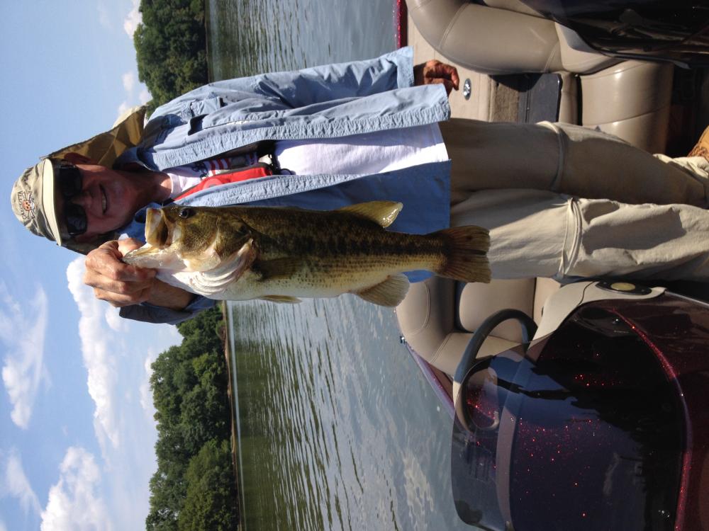
Shaky Head using a Zoom green pumpkin trick worm on a jig head next to a metal dock on the Historic James River. Weighed in at 4.5 pounds.
-
Glenn, when you attend the Classic could you ask the reel manufacturers if there is any way they could add a line counter to their reels? Some saltwater reels have a spool counter so the technology is there. And yes, a line counter on a reel will increase its weight but we will offset that deficiency with the knowledge that we have the correct amount of line on our reels. Individual line counters are of poor construction and difficult to master. Just a suggestion. Looking forward to the gang's input, too. Thanks and have a fun time at the Classic.
-
Wxrisk.com 2 hrs · *** ALERT ** 12z GFS ENSEMBLE just went " woof " for ACCUMULATING SNOW for much of VA MD PA eastern WVA on JAN22 ... this matches the EURO ensembles over the past few runs and now that this event is 6 days away the models are really beginning to "see it".... This may be the only chance for the Middle Atlantic region this winter. I do not think that is going to be the case but it is possible. In the super strong El Nino events in the winter of 1982 - 83 and in ...the winter of 1997- 98 there was one and only one significant East Coast winter storm in each of those winters. Outside of those brief windows of winter, those winters on the East Coast were pretty mild and snowless. I still believe that there will be another buildup of the pattern which will bring back another 3 or 4 window of winter opportunities covering much of February and or March. But given the amount of cold air coming into the middle Atlantic JAN 17-20 this JAN22 threat seems to be increasing. See More 2
-
Did you see Bobby? I walked around two times and could not find his booth.
-
Go for the first option and send pics when finished.
-
Troy, are you going to the Richmond Fishing Expo? If so, check out Sturgeon Creek Marina's booth. They have flyers on the Lake Anna tournaments. You can also talk to the guys about One Fish Anna. If you cannot attend the event you can PM me your email address and I can scan and email copies of the flyers to you.
-
Sorry, but I don't see any problem. Sounds like you are doing the right thing. Also sounds like a lot of us guys. Keep on trucking!
-
UPDATE ON JAN 22-23 THREAT... PLEASE SCROLL DOWN TO SEE PREVIOUS POST ( LETS MONGER ) not much to change - The "regular " euro model holds OR keeps the southern Low back over TX for an Extra 1-2 days so it arrives on JAN 24 and all the cold air is gone from the east coast and even new England !.... But the Euro Ensemble does NOT do this... It has the southern Low arriving much faster with the cold air still in place over the eastern third of the US which results in significant snow ice for VA MD WVA TN DEL and western NC ... in addition this colder wintry solution is supported by the GFS ensemble as well
-
Would expect dinks at Lafreniere Park. The Lagoon is big with lot of places to fish from St. Charles Avenue over towards Magazine Street. You can cast out to Monkey Island from the bank. Just make sure you have your fishing license as sometimes you will be checked. Let me know how you do.
-
We will get a little snow on the East Coast this Sunday so if you plan to go fishing pleae double check the weather. Dave at Wxrisk.com reported the hurricane two days ago but it looks like it will not hit the US. But stay tuned. Here is Dave's weather forecast for this Sunday: Wxrisk.com 9 hrs · BE ADVISED -- EXPECT PERIODS OF LIGHT SNOW / SNOW SHOWERS JAN 17 off and on all day over Western/ central NC ... Much of VA intro Lower MD eastern shore